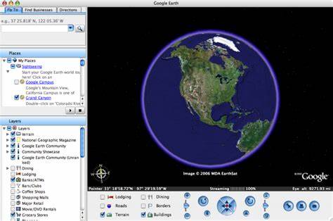
Google Earth является одним из самых популярных инструментов для изучения нашей планеты в цифровом формате. С тех пор как он был запущен, сервис претерпел множество обновлений и дополнений, предлагая пользователям широкий спектр версий и функций, которые удовлетворяют разнообразные потребности – от простого просмотра спутниковых снимков до создания профессиональных карт и анализа геоданных. В этом обзоре мы подробно рассмотрим все актуальные версии Google Earth, их предназначение, особенности, преимущества и потенциальные варианты использования. Для многих пользователей самым доступным и привычным вариантом является Google Earth Web. Эта версия работает напрямую в браузере Chrome, позволяя в считанные секунды «перелетать» с одного места на Земле в другое, наслаждаясь детализированной трехмерной графикой сотен городов и природных объектов.
Ее главный плюс заключается в отсутствии необходимости устанавливать дополнительное программное обеспечение, что делает сервис мгновенно доступным практически с любого устройства. Веб-версия также предлагает инструменты для создания собственных виртуальных туров и маршрутов, включая возможность развлекательного «случайного» путешествия по новым и неизвестным локациям. Следующий популярный вариант – Google Earth Mobile, оптимизированный для смартфонов и планшетов на платформах iOS и Android. Современные мобильные устройства позволяют пользователям буквально в одно касание погружаться в реалистичные изображения, панорамные фотографии и трехмерные модели городов или природных ландшафтов. Простота интерфейса и удобство навигации делают этот вариант незаменимым для путешественников, студентов и всех, кто хочет открыть для себя мир с помощью функционального и интуитивного приложения.
Для скачивания достаточно посетить Apple App Store или Google Play, где доступны последние версии с новыми обновлениями и исправлениями багов. Для профессионалов и продвинутых пользователей Google предлагает Google Earth Pro Desktop – бесплатную десктопную программу с расширенным набором инструментов. Этот софт подходит географам, экологам, городским планировщикам и всем, кто работает с геоинформационными системами (ГИС). Вполне понятно, что здесь предусмотрена возможность импорта и экспорта ГИС-данных, что значительно облегчает анализ больших массивов информации и построение сложных моделей. Еще одна уникальная функция – доступ к историческим спутниковым снимкам, позволяющим видеть, как менялись территории и инфраструктура с течением времени.
Программа совместима с Windows, macOS и Linux, что расширяет круг пользователей данного решения. Beyond the core versions of Google Earth, Google has developed specialized tools that cater to various professional and creative needs. Earth Studio is a browser-based animation tool that allows content creators to generate stunning visual presentations and in-depth geographic storytelling. It is widely used in media and educational projects to create dynamic flyovers, zoom-ins, and transitions within Earth’s 3D environment. Earth Engine targets scientists and researchers engaged in large-scale satellite data analysis and environmental monitoring, offering powerful cloud computing capabilities to process terabytes of imagery.
Another fascinating facet is Earth VR, which provides a virtual reality experience of our planet. This immersive tool enables users to explore natural wonders, urban landscapes and remote regions from the comfort of their VR-equipped device. Such technology brings a new dimension to education, tourism and even policy awareness by delivering an up-close perspective of climate change effects and geographical phenomena. Additionally, Google Earth Outreach serves non-profit organizations and community groups, equipping them with mapping resources to support humanitarian projects, environmental campaigns and social initiatives. This version underscores Google’s commitment to social impact by enabling users to visualize and share critical information on a global platform.
From casual explorers wandering the globe via web or mobile, to professionals leveraging precise GIS functions, each Google Earth version fills a unique niche. Features like Voyager tours provide guided experiences ranging from historical journeys to cultural showcases, enriching the user's knowledge and engagement with the planet. Creating custom maps and tours enables educators and enthusiasts to personalize their explorations or share stories with audiences. Looking ahead, Google continues to develop and expand its Earth-related products, with plans to enhance browser compatibility beyond Chrome and introduce new interactive features. Such efforts guarantee wider accessibility and improved user experiences.
Data privacy and terms of use are also carefully managed, ensuring that users’ rights are protected while benefiting from the vast wealth of geographical information. In conclusion, Google's ecosystem centered around Earth versions is designed to meet the diverse demands of a global audience, from novice travelers and students to experts and organizations. Its multifaceted tools and platforms provide unparalleled opportunities to explore, understand and visualize our planet. Whether on a smartphone, desktop, browser or virtual reality headset, Google Earth empowers users to embark on immersive journeys, conduct detailed research and creatively share their findings with the world.